
How to Cite
Abstract
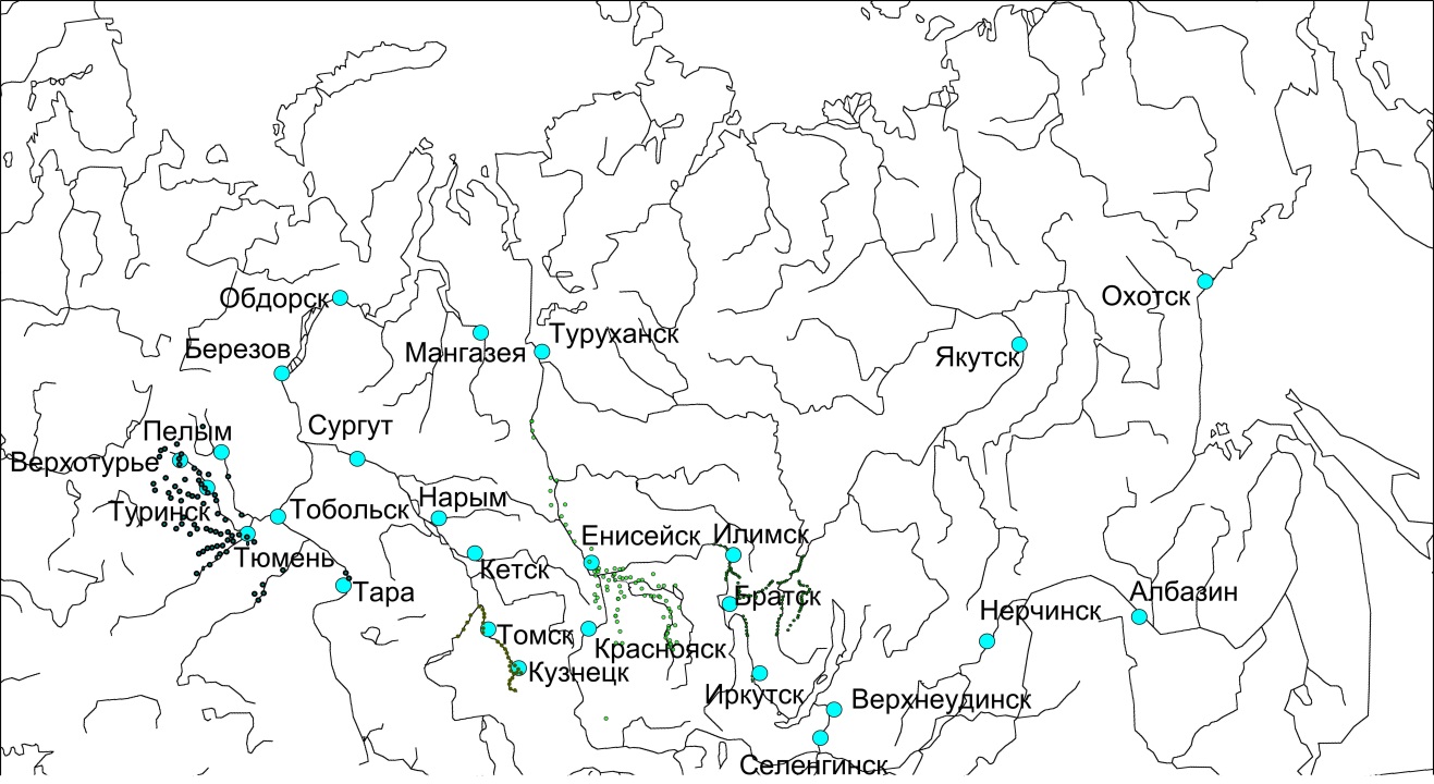
The article discusses the problem of mapping Russian agrarian coloanization of Siberia in the XVII century. For this purpose, the article reviews the attempts of mapping of rural settlements of the XVII century, which were made in the period 1947 -2010
By the end of the XVIII century the Russian population in Siberia was formed. This population was distributed extremely unevenly, concentrating mainly in several districts (uezds) of Western Siberia. This situation was directly related to agrarian colonization.
When the study of this process began, scholars drew several maps of the XVII century Russian agrarian colonization of Siberia. The most detailed map, with more than 200 settlements, was compiled by V.N. Sherstoboev for Ilimsk district (uezd).
V. N. Shunkov made maps for all five agrarian regions of Siberia. Best of all, he mapped the most populous in the XVII century region: Tobolsk and Verkhotur’e. This area remained the most important throughout the XVII century.
In the book written by V.A. Aleksandrov, a very detailed map of populated areas of the Yenisei agricultural region was given, which does not coincide with the data of V.N. Shunkov.
In 1999, a map compiled in the first half of the XX century using two sources from the beginning of the XVIII century of settlements around the city of Kuznetsk was published.
All areas except Ilimsk are mapped poorly, so our attempt to draw a map of agrarian colonization is only preliminary and is more a question than an answer.
References
Александров, В. А. (1964). Русское население Сибири XVII - начала XVIII в. (Енисейский край). В Труды Института этнографии им. Н. Н. Миклухо-Маклая. Новая серия/ Акад. наук СССР; Т. 87. Москва: Наука.
Клочков, М. (1911). Население России при Петре Великом по переписям того времени (Т. 1). Спб.
Окладников , А. П. (1968). История Сибири с древнейших времен до наших дней: Сибирь в составе феодальной России (Т. 2). (А. П. Окладников, & В. И. Шунков, Ред.) Ленинград: Наука. Ленингр. отд-ние.
Панов, В. И. (1999). История заселения Кузнецкого района (XVII – начало XX в.): областной и этнический состав переселенцев. В Н. А. Кузнецов (Ред.), Кузнецкая старина. Вып. 3. (стр. 36-52). Новокузнецк: Кузн. крепость.
Хромых, В. В., & Хромых, О. В. (2011). Ландшафтный анализ Нижнего Притомья на основе ГИС: естественная динамика долинных геосистем и их изменения в результате антропогенного воздействия. Томск: Изд-во НТЛ.
Шерстобоев, В. Н. (1949). Илимская пашня. Т. 1. Пашня Илимского воеводства XVII и начала XVIII века. Иркутск: Иркутское областное издательство.
Шунков, В. И. (1956). Очерки по истории земледелия Сибири (XVII век). (М. Н. Тихомиров, Ред.) М.: Издательство Академии наук СССР.
References
Aleksandrov, V. A. (1964). Russian population of Siberia XVII - the beginning of the XVIII century. (Yenisei Territory). In Proceedings of the Institute of Ethnography. N.N. Miklouho-Maclay. New series / Acad. sciences of the USSR; T. 87. Moscow: Science.
Klochkov, M. (1911). The population of Russia under Peter the Great according to the census of that time (Vol. 1). SPb.
Okladnikov, A. P. (1968). The history of Siberia from ancient times to the present day: Siberia as part of feudal Russia (T. 2). (A. P. Okladnikov, & V. I. Shunkov, Ed.) Leningrad: Science. Leningrad detachment
Panov, V. I. (1999). The history of the settlement of the Kuznetsk region (XVII - early XX century.): Regional and ethnic composition of immigrants. In N. A. Kuznetsov (Ed.), Kuznetsk old. Issue 3. (pp. 36-52). Novokuznetsk: Kuzn. fortress.
Khromykh, V. V., & Khromykh, O. V. (2011). Landscape analysis of the Lower Pritomye based on GIS: natural dynamics of valley geosystems and their changes as a result of human impact. Tomsk: Publishing house NTL.
Sherstoboev, V. N. (1949). Ilim arable land. T. 1. Arable land of the Ilim province of XVII and the beginning of the XVIII century. Irkutsk: Irkutsk Regional Publishing House.
Shunkov, V. I. (1956). Essays on the history of agriculture in Siberia (XVII century). (M. N. Tikhomirov, Ed.) M.: Publishing House of the Academy of Sciences of the USSR.

This work is licensed under a Creative Commons Attribution-NonCommercial-NoDerivatives 4.0 International License.